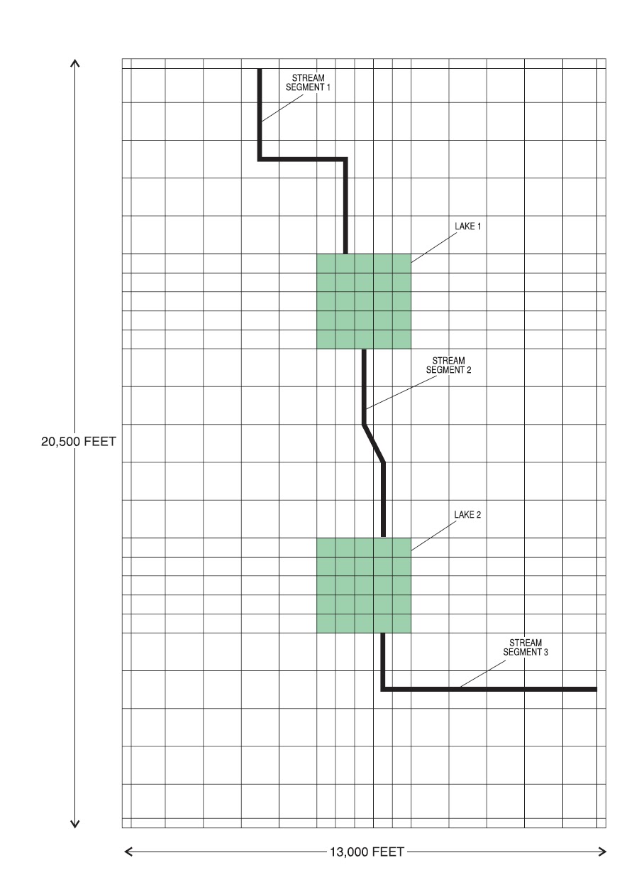
The example problem is from simulation 2 of official lake package documentation. There are two lakes and three streams connection them. Flow direction is from north to south.
Some terminologies to know. GMS's wiki page explains them pretty well.
"A stream network is composed of reaches and segments. A reach is the portion of a stream that lies inside a single cell. A single cell may contain multiple reaches. A segment is a group of reaches that forms one section of the stream. The reaches within a segment are always numbered from upstream to downstream. The segments should also be numbered from upstream to downstream."
In the figure below. There are three stream segments. And Segment 1 has 8 reaches (stream covers 8 cells). Reaches are numbered sequentially from upstream to downstream.
All right, let's get to the files. Only a brief description is provided here and emphasis is on converting STR file to SFR file. Detailed descriptions of each parameter can be found in official SFR package doc page 40.
SFR package has five ways of calculating stream depth, flagged by ICALC in the input file. Manning equation with rectangle stream channel (ICALC=1) is used here. This option is also supported in STR package. Also, things get complicated when tributaries and diversions are involved. The example has no tributary or diversion involved. Stay tuned for part 2 of this post about tributary and diversion.
SFR file:
22,3,0,0,128390.4,.0001,-1,0
Explanation
22-Total # of reaches, 3-Total # of segments, these two need to be change for each simulation
0, 0 -keep 0 if steady-steate and parameters same within a segment, 128390.4-this is the constant conversion factor if Manning equation is used (it's equal to 1.485*86400 if unit is specified in days), 0.0001-tolerance, not changed in most cases, -1, 0- output control.
1,2,5,1,1,1000. ;segment and reach identification and reach length
1,3,5,1,2,1000. ; layer, row, column, segment, reach, reach length
1,4,5,1,3,1000.
1,4,6,1,4,1000.
1,4,7,1,5,500.
1,4,8,1,6,750.
1,5,8,1,7,1000.
1,6,8,1,8,1000.
1,12,9,2,1,1000.
1,13,9,2,2,1000.
1,14,10,2,3,559.
1,14,10,2,4,559.
1,15,10,2,5,1000.
1,16,10,2,6,1000.
1,22,10,3,1,1000.
1,23,10,3,2,750.
1,23,11,3,3,500.
1,23,12,3,4,1000.
1,23,13,3,5,1000.
1,23,14,3,6,1000.
1,23,15,3,7,1000.
1,23,16,3,8,1000.
3,0,0 ;3-number of segments, 0,0-read and print flags, see page 50 of doc for details
1 1 -1 0 691200.0 0.0 0.0 0.0 0.05 ;flow and environmental data for segment 1
Explanation.
1-segment number,
1-ICALC,
-1, OUTSEG, where stream is connected downstream. Negative means connection to lake, 0 means connect to nothing. In this case, it is connected to Lake 1,
0, INSEG, where stream is connected upstream. Same format as OUTSEG
691200.0, FLOW, flow into 1st reach.
0.0 0.0 0.0 - runoff, evaporation, precipitation
0.05- Manning roughness coefficient
0.50,0.50,124.5,5.0 ;upstream stream channel information for segment 1
0.50-
0.50-stream bed thickness
124.5-elevation of top of stream bed
5.0-channel width
0.50,0.50,116.5,5.0 ;downstream stream channel information for segment 1
2 1 -2 -1 0.0 0.0 0.0 0.0 0.05 ;flow and environmental data for segment 2
0.50,0.50,114.85,5.0 ;upstream stream channel information for segment 2
0.50,0.50,110.65,5.0 ;downstream stream channel information for segment
3 1 0 -2 0.0 0.0 0.0 0.0 0.05 ;flow and environmental data for segment 3
0.50,0.50,109.4286,5.0 ;upstream stream channel information for segment 3
0.50,0.50,102.5714,5.0 ;downstream stream channel information for segment 3
STR file:
PARAMETER 0 0
22 3 0 0 1 1.28383e5 154 155
Explanations
22-total number of reaches
3-total number of segments
0-total number of tributaries
0-total number of divesions
1-ICALC see explanation from above
1.28383e5-constant = 1.486*86400 if ICALC = 1
154,155-output units
22 0 0 ; read and printing flags, 22 is total number of reaches
1 2 5 1 1 6.9e5 0. 4.72046e3 1.235e2 1.24e2
Explanation: lay,row,col,segment,reach,flow, stage(0=to be calculated), bottom of streambed, top of streambed
1 3 5 1 2 0. 0. 5.00033e3 1.2238e2 1.2288e2
1 4 5 1 3 0. 0. 4.57631e3 1.2126e2 1.2176e2
1 4 6 1 4 0. 0. 5.00038e3 1.2014e2 1.2064e2
1 4 7 1 5 0. 0. 2.50019e3 1.193e2 1.198e2
1 4 8 1 6 0. 0. 4.32848e3 1.1874e2 1.1924e2
1 5 8 1 7 0. 0. 5.e3 1.1762e2 1.1812e2
1 6 8 1 8 0. 0. 5.87008e3 1.165e2 1.17e2
1 12 9 2 1 0 0. 4.74142e3 1.14e2 1.145e2
1 13 9 2 2 0. 0. 5.00041e3 1.13222e2 1.13722e2
1 14 10 2 4 0. 0. 2.47465e3 1.12056e2 1.12556e2
1 15 10 2 5 0. 0. 5.012e3 1.11278e2 1.11778e2
1 16 10 2 6 0. 0. 4.52491e3 1.105e2 1.11e2
1 22 10 3 1 0. 0. 4.34095e3 1.085e2 1.09e2
1 23 10 3 2 0. 0. 4.92948e3 1.07627e2 1.08127e2
1 23 11 3 3 0. 0. 2.50026e3 1.07191e2 1.07691e2
1 23 12 3 4 0. 0. 5.00051e3 1.06536e2 1.07036e2
1 23 13 3 5 0. 0. 5.00051e3 1.05664e2 1.06164e2
1 23 14 3 6 0. 0. 5.00051e3 1.04791e2 1.05291e2
1 23 15 3 7 0. 0. 5.00051e3 1.03918e2 1.04418e2
1 23 16 3 8 0. 0. 5.00051e3 1.03045e2 1.03545e2
1 23 17 3 9 0. 0. 8.65081e1 1.025e2 1.03e2
5. 1.12e-3 5.e-2 ; width, slope(STR only), manning roughness
5. 1.12e-3 5.e-2
5. 1.12e-3 5.e-2
5. 1.12e-3 5.e-2
5. 1.12e-3 5.e-2
5. 1.12e-3 5.e-2
5. 1.12e-3 5.e-2
5. 1.12e-3 5.e-2
5. 7.7778e-4 5.e-2
5. 7.7778e-4 5.e-2
5. 7.7778e-4 5.e-2
5. 7.7778e-4 5.e-2
5. 7.7778e-4 5.e-2
5. 7.7778e-4 5.e-2
5. 8.7273e-4 5.e-2
5. 8.7273e-4 5.e-2
5. 8.7273e-4 5.e-2
5. 8.7273e-4 5.e-2
5. 8.7273e-4 5.e-2
5. 8.7273e-4 5.e-2
5. 8.7273e-4 5.e-2
5. 8.7273e-4 5.e-2
5. 8.7273e-4 5.e-2
Now that we have looked at both files, let's make SFR file out of a STR
1) header line 22,3,0,0,128390.4,.0001,-1,0. Change 22, 3 according to model. Leave the printing flags as default if you don't need them.
2) add the chuck of data about location and length of each reach. The first five integers of each reach record is the same for SFR and STR, copy them over. The fifth number in the SFR file is reach length which is not specified in STR. You have to make something up. Maybe use size of the cell.
1,2,5,1,1,1000.
1,3,5,1,2,1000.
1,4,5,1,3,1000.
1,4,6,1,4,1000.
1,4,7,1,5,500.
...
- another line about printing flags
3) 3,0,0 change 3 to appropriate total number of segments
4) now enter data about each segment. Ready to do some work... See above for parameter description.As you may have noticed already, unlike SFR there is no information about things like connection to lake, runoff, evaporation, precipitation in the STR file, so yo have to enter these information yourself One of the important parameter for lake interaction is the 3rd one, -1 here. It means stream is connection to lake number 1.
1 1 -1 0 691200.0 0.0 0.0 0.0 0.05
5) next line is information about upstream reach of the segment. The streambed top and bottom are included in STR file.
5) next line is information about upstream reach of the segment. The streambed top and bottom are included in STR file.
6) next line is information about downstream reach of the segment.
7) now repeat 4) to 6) for every other segment.
Done. Now if you comment out the STR file in the NAM file and add name of SFR file, it should just run.
Leave a comment if you have any questions.